-
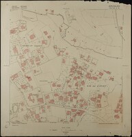
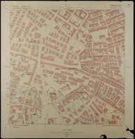 Map of Jerusalem (1:1250), District 170-130. Sub-District 5. D., Surveyed 1936, Published 1938
 Map of Jerusalem (1:1250), District 170-130. Sub-District 5. D., Surveyed 1936, Published 1938. Undertaken by Survey of Palestine.
-
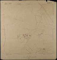
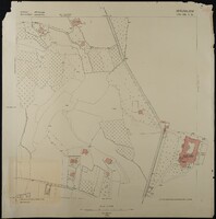
 Map of Jerusalem (1:1250), District 170-130. Sub-District 6. A., Surveyed 1936, Published 1938
 Map of Jerusalem (1:1250), District 170-130. Sub-District 6. A., Surveyed 1936, Published 1938. Undertaken by Survey of Palestine.
-
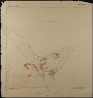
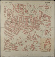
 Map of Jerusalem (1:1250), District 170-130. Sub-District 6. B., Surveyed 1935, Published 1938
 Map of Jerusalem (1:1250), District 170-130. Sub-District 6. B., Surveyed 1935, Published 1938. British Administration: Survey of Palestine.
-
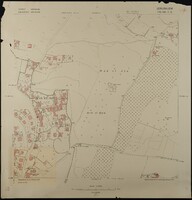
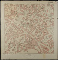
 Map of Jerusalem (1:1250), District 170-130. Sub-District 6. C., Surveyed 1936, Published 1938
 Map of Jerusalem (1:1250), District 170-130. Sub-District 6. C., Surveyed 1936, Published 1938. Undertaken by Survey of Palestine.
-
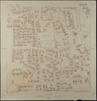
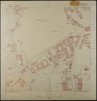
 Map of Jerusalem (1:1250), District 170-130. Sub-District 6. D., Surveyed 1936, Published 1938
 Map of Jerusalem (1:1250), District 170-130. Sub-District 6. D., Surveyed 1936, Published 1938. Undertaken by Survey of Palestine.
-
 Map of Jerusalem (1:1250), District 170-130. Sub-District 7. A., Surveyed 1935, Published 1938
 Map of Jerusalem (1:1250), District 170-130. Sub-District 7. A., Surveyed 1935, Published 1938. Undertaken by Survey of Palestine.
-
 Map of Jerusalem (1:1250), District 170-130. Sub-District 7. B., Surveyed 1936, Published 1938
 Map of Jerusalem (1:1250), District 170-130. Sub-District 7. B., Surveyed 1936, Published 1938. Undertaken by Survey of Palestine.
-
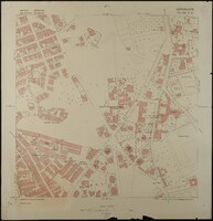
 Map of Jerusalem (1:1250), District 170-130. Sub-District 7. C., Surveyed 1936, Published 1938
 Map of Jerusalem (1:1250), District 170-130. Sub-District 7. C., Surveyed 1936, Published 1938. Undertaken by Survey of Palestine.
-
 Map of Jerusalem (1:1250), District 170-130. Sub-District 7. D., Surveyed 1936, Published 1938
 Map of Jerusalem (1:1250), District 170-130. Sub-District 7. D., Surveyed 1936, Published 1938. Undertaken by Survey of Palestine.
-
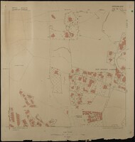
 Map of Jerusalem (1:1250), District 170-130. Sub-District 9. A., Surveyed 1936, Published 1938
 Map of Jerusalem (1:1250), District 170-130. Sub-District 9. A., Surveyed 1936, Published 1938. Undertaken by Survey of Palestine.
-
 Map of Jerusalem (1:1250), District 170-130. Sub-District 9. B., Surveyed 1936, Published 1938
 Map of Jerusalem (1:1250), District 170-130. Sub-District 9. B., Surveyed 1936, Published 1938.
-
 Map of Jerusalem (1:1250), District 170-130. Sub-District 9. C., Surveyed 1936, Published 1938
 Map of Jerusalem (1:1250), District 170-130. Sub-District 9. C., Surveyed 1936, Published 1938. Undertaken by Survey of Palestine.
-
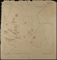
 Map of Jerusalem (1:1250), District 170-130. Sub-District 9. D., Surveyed 1935, Published 1937
 Map of Jerusalem (1:1250), District 170-130. Sub-District 9. D., Surveyed 1935, Published 1937. Undertaken by Survey of Palestine.
-
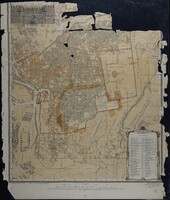
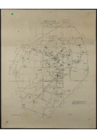
 Map of Jerusalem (1:20,000) Index: Survey of Urban Area, 1939
 Map of Jerusalem (1:20,000) Index: Survey of Urban Area, 1939. Undertaken by Survey of Palestine.
-
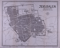
 Map of Jerusalem (1:2500); The Old City, Surveyed 1936, Published 1967.
 Map of Jerusalem (1:2500); The Old City, Surveyed 1936, Published 1967. Compiled, Drawn & Printed under the direction of F.J. Salmon, Commissioner for Lands & Surveys, Palestine, 1936. Revised from information supplied by Dept. of Antiquities, 1945. Modified reprint May 1947. Printed by Survey of Israel, June 1967.
-
 خريطة مدينة القدس (١٩٤١)
 خريطة القدس. البلدة القديمة كما تظهر من باب الخليل. من كتاب 'دليل فلسطين' (١٩٤١) للكاتب زيف فيلناي، تم رسم الخريطة من قبل بن ديفيد, ويشمل الحرم الشريف ولكنه يركز بشكل كبير على الأماكن ذات الأهمية اليهودية والمسيحية
-
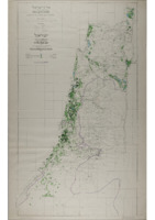 خريطة فلسطين؛ المناطق المروية (١٩٥٥)
 1:250,000 scale map of irrigated areas in Palestine, with text in English and Hebrew, printed in 1955. Contains an index to Villages & Settlements, and a Map of Irrigated Areas. Published by the Ministry of Agriculture - Water Department, Water Utilisation Division. Compiled, Drawn & Printed by the Survey of Palestine, 1946.
-
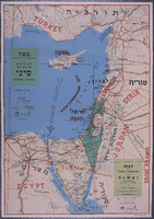 خريطة الحملة الإسرائيلية في شبه جزيرة سيناء (١٩٥٦)
 خريطة الحملة الإسرائيلية في شبه جزيرة سيناء، توضح تحركات القوات من ٢٩ أكتوبر إلى ٥ نوفمبر ١٩٥٦، مكتوبة بالعبرية والإنجليزية
-
 Maps of Jerusalem (1:1250), Districts 165-130 & 170-130. Surveyed 1935-1937, Published 1937-1938.
 Maps of Jerusalem (1:1250), Districts 165-130 & 170-130. Surveyed 1935-1937, Published 1937-1938. A full PDF containing the 37 maps of Jerusalem which originate from the Palestine survey in the 1930's under British Administration, covering districts 165-130 & 170-130. The maps start with the index and run in numerical order of District, then Sub-District.