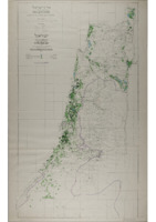
Map of Palestine; Irrigated Areas, 1:250,000. 1955.
Item
-
Description
-
1:250,000 scale map of irrigated areas in Palestine, with text in English and Hebrew, printed in 1955. Contains an index to Villages & Settlements, and a Map of Irrigated Areas. Published by the Ministry of Agriculture - Water Department, Water Utilisation Division. Compiled, Drawn & Printed by the Survey of Palestine, 1946.
-
Spatial Coverage
-
Palestine
-
Subject
-
Agriculture and Fishing
-
Palestine
-
Jerusalem
-
Politics
-
Creator
-
Compiled, Drawn & Printed by the Survey of Palestine
-
Date
-
1955
-
Identifier
-
MS 115/41/3
- Resource class
- Image


